The Deadliest Threat to Life in a Hurricane
If you've ever asked what is the biggest threat to life in a hurricane, the answer probably isn't what you expect. It's not the howling wind, the debris slicing through the air, or the tornadoes that sometimes spin off a storm's edges. The real killer is water, and it claims lives in ways that most people never see coming.
The numbers back this up in a big way. According to the National Hurricane Center, water has been responsible for nearly 90% of all tropical cyclone fatalities in the United States over the past several decades. That statistic holds true even as wind speeds climb and storm categories rise.
The danger isn't the number you hear on the news; it's what the water does to you, your home, and the roads you thought were safe. Let's break down exactly why water is so deadly and how to recognize the specific scenarios that put your life at risk.
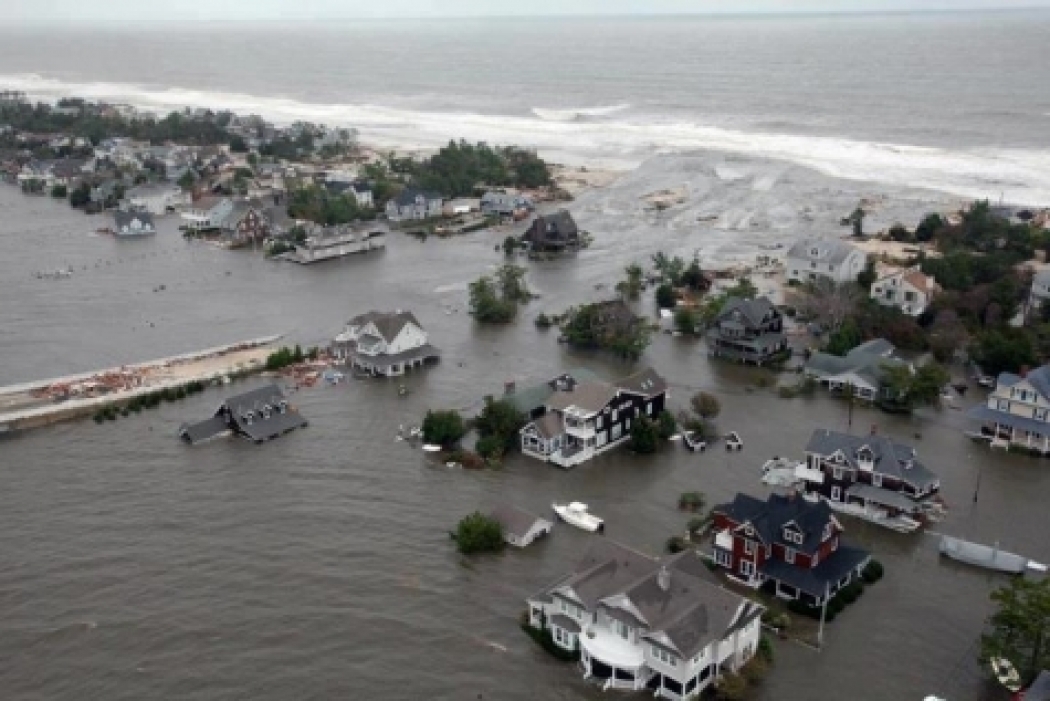
Image source: Web (Bing) / climatecentral.org (Web image (fair-use with source credit))
Quick Answer
Storm surge and inland flooding cause most hurricane deaths. Wind is not the primary killer. Water rises fast and catches people off guard.
Knowing the water threat saves lives. Every household in a hurricane zone needs a well-prepared emergency kit.
The Real Killer in Hurricanes Isn’t the Wind
Most of us grew up watching news coverage of hurricanes focused entirely on wind. Reporters stand in howling gales while palm trees bend sideways, and the Saffir-Simpson category number gets repeated like a warning siren. That category, however, only tells you the maximum sustained wind speed.
It says nothing about the wall of ocean water pushing ashore or the feet of rain falling hundreds of miles inland.
The obsession with wind leads to a dangerous mental shortcut. People hear "Category 1" and think they can ride out the storm at home. They board up windows and stock up on batteries, then feel confident.
What they don't realize is that a slow-moving Category 1 storm can push a devastating surge into the coast while dumping enough rain to flood entire neighborhoods. Wind can tear off a roof. Water can make your house disappear.
Emergency managers across the Gulf Coast and Eastern Seaboard have spent years trying to shift this mindset. Their message is simple and consistent: water, not wind, is what kills you. If you're in an evacuation zone for surge, leaving early is the only move that matters.
Your hurricane plan should start with understanding your water risk, not the forecast wind speed. That means knowing whether you live in a storm surge evacuation zone and whether your area is prone to flash flooding. It means treating every hurricane as a water event first, no matter the category.
What the Numbers Actually Show: Water Causes Nearly All Deaths
The data leaves little room for debate. When researchers look at direct hurricane fatalities in the United States, water dominates the breakdown by a huge margin. Storm surge alone has historically accounted for roughly half of all deaths.
Inland freshwater flooding adds another large slice, often from rainfall that catches people off guard far from the coastline.
To put it in perspective, here's how direct fatalities typically stack up based on long-term analyses:
| Primary Cause | Approximate Share of Direct Deaths |
|---|---|
| Storm surge | ~50% |
| Inland flooding (rainfall) | ~27% |
| Wind | ~8% |
| Tornadoes | ~5% |
| Other (including post-storm accidents) | ~10% |
These percentages shift slightly from decade to decade, but the pattern never changes. Water kills far more people than wind. Even in high-category storms, surge and freshwater flooding are the leading causes of death.
Wind-related fatalities, while tragic, are a small fraction of the total.
A common misunderstanding is that the strongest hurricanes produce the most surge. In reality, surge depends on a storm's size, forward speed, angle of approach, and the shape of the coastline. A large Category 2 storm hitting a shallow shelf can generate a much higher surge than a compact Category 5 that moves quickly over deep water.
That's why evacuation decisions are based on storm surge watches and warnings, not just the category number. If you're waiting for a Category 5 to evacuate, you might already be trapped by water.
Storm Surge: The Deadliest Force Most People Understand Poorly
Storm surge is not a wave. It's a rise in ocean water level pushed ashore by a hurricane's winds and low pressure. Think of it as the ocean itself lifting up and swallowing the coast.
This water can move miles inland, turning streets into rivers and ground floors into underwater traps.
The surge arrives ahead of the storm's center, often when the sky still looks manageable. People step outside to check damage and find themselves chest-deep in moving water within minutes. The speed is what makes it so lethal.
You don't have to live on the beach to be at risk. In low-lying areas like parts of southeastern Louisiana or coastal Texas, surge can push 10 to 20 miles inland. The water doesn't just rise, it flows with tremendous force, capable of sweeping cars away and collapsing buildings from the bottom up.
Several factors make surge worse. A shallow continental shelf off the coast of the Gulf of Mexico allows water to pile up higher than it would along the steeper Atlantic shelf. A storm that moves slowly, or stalls just offshore, has more time to push water toward land.
The angle of approach matters too, with a perpendicular hit often focusing surge into a narrow, destructive zone. All of these details get lost when someone focuses solely on the category number.
That's why having a plan and knowing your evacuation zone is critical, as we cover in our guide to a well-stocked hurricane kit. Your kit should reflect the water threat, including items like life preservers, waterproof bags for documents, and a way to signal for help if you're trapped. If local officials issue a surge warning for your area, treat it as a mandatory call to leave.
The water won't wait for you to finish packing.
Inland Flooding: Why You Don’t Need to Live Near the Ocean to Drown
If you live a hundred miles from the coast, you might feel a false sense of security when a hurricane is bearing down. That feeling can be deadly. Inland flooding from rainfall is one of the most underestimated threats a tropical cyclone produces.
All that water has to go somewhere, and it often ends up in rivers, creeks, and urban drainage systems that can't handle the volume.
Hurricane Harvey in 2017 is a textbook example. The storm made landfall as a Category 4 near Rockport, Texas, then stalled for days, dumping more than 60 inches of rain over parts of Houston and surrounding areas. The result was catastrophic freshwater flooding that displaced thousands and killed 68 people, most from drowning in homes and vehicles.
The National Hurricane Center's post-storm report made it clear: this was a water disaster, not a wind disaster.
Slow-moving storms and tropical systems that interact with other weather features can produce extreme rainfall far inland. Hurricane Florence in 2019 brought record rainfall to the Carolinas, causing rivers to crest days after the storm passed. People who had never flooded before found themselves wading through chest-high water.
The danger isn't just deep water, it's moving water. Just six inches of fast-moving water can knock an adult off their feet. Two feet of water will float a sedan.
This is where preparation takes on a different shape. You don't need a boat in your garage, but you do need emergency supplies for flooding ready to grab. Think about waterproof boots, a flashlight with extra batteries, and a plan for getting to higher ground without driving through flooded roads.
The "Turn Around Don't Drown" campaign exists because so many deaths happen when people attempt to drive through water they think they can beat. The road may be washed out underneath, and the water is often deeper than it looks.
Why the Saffir-Simpson Scale Can Get You Killed
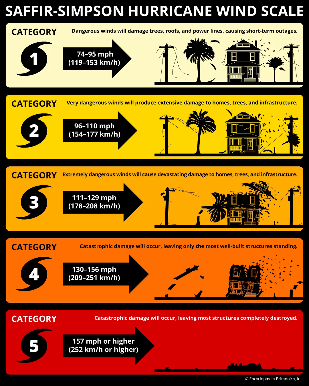
Image source: Web (Bing) / britannica.com (Web image (fair-use with source credit))
The Saffir-Simpson Hurricane Wind Scale ranks storms from 1 to 5 based solely on maximum sustained wind speed. It was created in 1971 by engineer Herbert Saffir and meteorologist Robert Simpson. At the time, it was a useful tool for giving the public a quick sense of potential wind damage.
Over the decades, however, it became the single number everyone latched onto, and that's where the trouble started.
The scale says nothing about storm surge height. It doesn't account for the size of the wind field, the forward speed of the storm, or the amount of rainfall it will produce. A compact Category 5 hurricane can have a tiny wind field and produce modest surge.
A sprawling Category 2 storm moving slowly toward a shallow coast can generate a catastrophic surge that far exceeds what the category implies. The National Hurricane Center has repeatedly pointed out these limitations, and they even stopped including storm surge in the scale back in 2010 because the correlation was so poor.
Despite these warnings, public perception hasn't caught up. Many people still believe a Category 1 or 2 storm is "not that bad" and choose to stay put. They focus on wind protection while ignoring the water risk entirely.
Emergency managers have told stories of residents who sandbagged their doors against wind-driven rain but never considered that a six-foot surge would make those sandbags irrelevant. The scale's simplicity is its greatest weakness, because it encourages a false sense of categorization.
Understanding your personal risk is the first step, and that includes having a ready-to-go kit packed before the storm threatens. If you wait until a hurricane warning is issued, it may be late to gather what you need. The same goes for your evacuation decision.
When you treat every hurricane as a potential water disaster, you're more likely to leave when you should. The National Hurricane Center's Saffir-Simpson overview makes it clear that wind speed alone is not the whole story. Let that sink in the next time you hear a storm's category on the news.
The Five Deadly Water Scenarios You Need to Recognize
Understanding the specific ways water kills during a hurricane helps you spot danger before it traps you. There are five scenarios that account for the vast majority of water-related fatalities, and each one follows a pattern you can learn to recognize.
1. Storm surge inundation of ground-floor homes. This is the classic surge death. Water rises faster than expected, trapping residents in their homes.
People who don't evacuate in surge zones often find themselves climbing to upper floors, then to attics, then to rooftops as water keeps rising. In Hurricane Katrina, many of the dead were found in attics where they'd retreated but couldn't escape.
2. Flash flooding in urban areas. Heavy rain overwhelms storm drains and turns streets into rivers in minutes. The water moves fast and carries debris.
People caught in low-lying intersections or underpasses can be swept away before they realize how deep it's gotten. This happens well inland, often in communities that never expected flooding.
3. River and creek flooding days after landfall. This is the delayed killer. Rainfall from a hurricane flows into river systems over days.
Rivers crest long after the wind has died down. People return home or move through flooded areas not realizing that the water is still rising and the ground is unstable. The danger peaks after the storm has left the headlines.
4. Vehicles swept away by floodwater. More than half of flood-related drownings happen in vehicles. Drivers misjudge depth, speed through water, or get trapped in their cars as they float and stall.
The vehicle often flips or gets wedged in a low spot, making escape impossible. This scenario plays out on highways, rural roads, and city streets alike.
5. People trapped in attics or upper floors during surge. When surge fills a home faster than residents can climb, they end up trapped with no way out. Cutting through a roof is difficult without tools, and waiting for rescue takes hours.
This scenario is especially deadly for elderly residents or those with mobility challenges who can't climb quickly.
Each of these scenarios shares a common thread: the water arrives faster than people expect, and the escape routes disappear before anyone reacts. That's why evacuation before the storm hits is the single most effective survival strategy. Having essential supplies ready gives you the confidence to leave early instead of waiting to see how bad it gets.
“Turn Around Don’t Drown”: The Rule That Saves Lives in Floodwater
The National Weather Service launched the "Turn Around Don't Drown" campaign because too many people were dying in completely avoidable ways. The rule is simple: never drive, walk, or wade through floodwater. No matter how familiar the road looks, no matter how shallow it seems, you're gambling with your life every time you move into moving water.
The physics are unforgiving. Six inches of fast-moving water can knock an adult off their feet. Twelve inches of water will float a small car.
Two feet of water will carry away most vehicles, including SUVs and trucks. The water hides road washouts, downed power lines, and open manhole covers. It only takes a moment of being swept off your feet for the current to pin you underwater.
Most vehicle-related flood deaths happen at night when drivers can't see the road. They think they know the route and drive straight into a flooded section that was perfectly dry the day before. The car stalls, water rises, and they're trapped.
Emergency responders see this pattern repeat storm after storm. The victims are often experienced local drivers who simply misjudged the depth.
Walking through floodwater is equally dangerous. The water is often contaminated with sewage, chemicals, and debris. Downed power lines can electrify the water without any visible warning.
People wading through what looks like a shallow puddle can step into a hidden ditch or get swept into a storm drain. The rule applies everywhere, from city sidewalks to rural roads.
Emergency managers have found that the most effective messaging is blunt. Signs on roads, warnings in weather alerts, and public service announcements all drive home the same point: if the water is covering the road, find another route or wait it out. No appointment, no errand, and no commute is worth your life.
The slogan works because it removes the guesswork. You don't need to measure the depth or test the current. If there's water on the road, you turn around.
Real Storms, Real Fatalities: When Water Killed and Wind Didn’t
The clearest way to understand hurricane fatalities is to look at what actually happened in specific storms. The patterns are consistent across decades and coastlines. Water kills, wind damages, and the gap between the two is enormous.
Hurricane Katrina in 2005 remains the most devastating example. The storm made landfall as a Category 3, but its massive size pushed a catastrophic storm surge into the Mississippi coast. The surge reached 20 to 28 feet in some areas, obliterating entire neighborhoods.
In Louisiana, levee failures flooded 80% of New Orleans. The official death toll surpassed 1,800, with drowning as the leading cause. Many victims were elderly residents who couldn't evacuate or climb to higher ground.
Hurricane Harvey in 2017 tells a different water story. The storm made landfall as a Category 4 near Rockport, Texas, but the wind damage was localized. The real disaster unfolded over the following days as Harvey stalled and dumped unprecedented rainfall on Houston and surrounding areas.
Some locations recorded more than 60 inches of rain. The freshwater flooding killed 68 people, most from drowning in homes and vehicles. The storm caused an estimated $125 billion in damage, with the vast majority from water, not wind.
Hurricane Florence in 2019 followed a similar inland flooding pattern. The storm weakened to a Category 1 before landfall in North Carolina, but it moved slowly and dumped record rainfall across the Carolinas. Rivers crested days after the storm passed, and many fatalities occurred in vehicles on flooded roads.
The death toll was 53, with drowning as the primary cause.
These storms share common elements. Each produced catastrophic water damage regardless of its peak wind intensity. Each caught residents off guard who had focused on the category number rather than the water threat.
And each generated fatalities far from the immediate coastline, in communities that didn't think they were at risk. The lesson is consistent: every hurricane is a water storm first.
How to Tell If Your Home Is in the Real Danger Zone
You can't prepare for a water threat you don't know you have. Figuring out your actual risk starts with understanding where you live, how water moves through your area, and what the official maps say about your property.
FEMA flood maps are the starting point. These maps identify Special Flood Hazard Areas, which are regions with a 1% or greater chance of flooding in any given year. You can look up your address on FEMA's Flood Map Service Center to see your base flood elevation and risk zone.
Keep in mind these maps have limitations. They don't account for every local drainage issue, and some areas flood repeatedly despite being mapped as low-risk.
Storm surge evacuation zones are separate from flood maps. These zones are based on hurricane storm surge models and are managed by local emergency management agencies. Zones are typically labeled A, B, C, and so on, with Zone A being the most vulnerable to surge.
You should know your zone before hurricane season starts. Your county or parish emergency management website will have a lookup tool.
Local knowledge matters too. Talk to neighbors who've lived in the area for decades. Ask which streets flood first, which intersections become impassable, and where water tends to pool during heavy rain.
Long-term residents often know things that maps don't capture. Check with your local government about recent drainage improvements or areas that have changed due to development.
If you're in a surge evacuation zone, your plan should include leaving when an evacuation order is issued. If you're in a flood-prone inland area, your plan should include routes to higher ground that don't cross known flood zones. Either way, you need an emergency kit ready to grab.
Waiting until the storm is approaching to figure out your risk is waiting too long. The National Hurricane Center's post-tropical cyclone reports detail what happened in past storms and can help you understand the patterns in your region.
Storm Surge Warnings, Flash Flood Emergencies, and When to Evacuate
Understanding the warning system is critical because the language meteorologists use directly reflects the level of danger. A watch means conditions are possible. A warning means they're happening or about to happen.
A flash flood emergency means people are in imminent danger of losing their lives.
The National Weather Service issues Storm Surge Watches and Warnings independently from hurricane wind warnings. A Storm Surge Watch means there's a possibility of life-threatening inundation from rising water moving inland within 48 hours. A Storm Surge Warning means that danger is expected within 36 hours.
These warnings are relatively new, having been separated from the general hurricane warning in 2017 to give the public a clearer picture of the water threat.
Flash Flood Emergencies are reserved for the most extreme situations. They're issued when catastrophic flooding is occurring or about to occur, and the threat to life is extreme. The National Weather Service doesn't use this designation lightly.
When you see it, you should already be in a safe location or moving to one immediately. People who wait for an emergency declaration before acting are often already trapped by rising water.
Evacuation timing depends on your location. If you're in a surge evacuation zone, you should leave before tropical storm-force winds arrive, usually 24 to 36 hours before the storm's center reaches the coast. Waiting for the wind to pick up means you're driving through dangerous conditions or stuck in traffic as the storm closes in.
Inland residents should focus on flash flood warnings and avoid travel during heavy rain.
The decision to leave should never depend on the storm's category alone. A Category 1 storm can produce a devastating surge if it's large and slow-moving. A Category 5 can be primarily a wind threat if it's compact and fast.
Your personal risk depends on where you live relative to the water, not the wind speed. If local officials issue an evacuation order for your zone, leave. Your home can be replaced.
You can't.
The Only Preparation Checklist That Actually Matches the Threat
Your kit should focus on water survival, not just wind. Pack documents in waterproof bags. Include life preservers for everyone in your household.
Add a flashlight, extra batteries, and a whistle. Keep a hand-crank radio for updates. Have a plan for getting to higher ground.
Know your evacuation zone before the storm forms.
Frequently Asked Questions
Is storm surge or wind more dangerous?
Storm surge kills more people than wind. It causes roughly half of all hurricane fatalities. Wind damage is costly but less deadly.
How far inland can flooding reach?
Heavy rain can flood areas hundreds of miles inland. Rivers crest days after landfall. Never assume distance from the coast makes you safe.
Should I drive through standing water?
No. Six inches can knock you down. Two feet floats a vehicle.
Turn around instead.
What does a Storm Surge Warning mean?
Life-threatening water rise is likely within 36 hours. Evacuate immediately if you're in the affected zone.